Monday, September 20, 2010
Great Aussie Adventure - Day 21
This morning was overcast and cool in Carnarvon when I woke up. After talking to the lady at the information center (she confirmed my fears about fuel and told me her similar story along the same drive!) I drove towards Macleoud Lake. On the way out of town, I passed another Big Thing, a Banana this time! I had written down a Big Apple, but it was definitely a banana!!!

As I got to the lake (it may be a salt lake), and was driving on a winding road, I came upon the Point Quobba Lighthouse. This is overlooking some pretty treacherous waters and several blowholes. This lighthouse is still in use, to the best of my knowledge. (Today was the first day that the Indian Ocean was not 14 different shades of green and blue - I guess only when the sun is out!) But it’s still beautiful. After finding the blowholes and shooting a few photos, it was back in the car for the drive to Exmouth.


Along the drive, there are sheep and goats and cows grazing right on the side of the road. I had watched an Australian movie called Charlie and Boots on this road trip. It’s about a father who is lost after his wife’s death and so his son takes him on a road trip. They had passed through some of the same towns I did on my trip!! A very funny part in the movie is when they’re driving and a lady who’s walking yells “PIG!” They turn to look at her and are concerned why she’s calling them pigs, but when they turn around, there is a pig standing in the road! As I was driving today, I had to laugh because the sheep, goats and cows just stand in the middle of the highway!! (But no one is calling me a cow!) Also along this drive up the peninsula to Exmouth is red dirt and red hills as far as the eye can see. I passed the Tropic of Capricorn (no big welcome this time, just a sign. There was a big welcome in QLD at the tropic.) It’s pretty, but after about the first 3 hours, it was the same old same old!
At the entrance to the town of Exmouth, there is a Big Prawn. These things are so funny!!

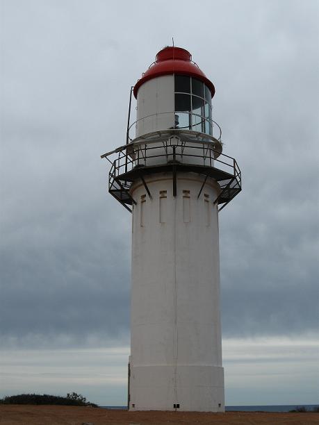
Once I got to Exmouth, I found Vlamingh Head Lighthouse. This one is also very nice. They are doing some construction to it as it has some weather damage.


“North-West Cape was first sighted in 1618 and Vlamingh Head was charted by Willem de Vlamingh in 1696. The Vlamingh Head Lighthouse was built in 1911-12 of concrete and contains a “Chance Bros” (Birmingham, UK) pre-fabricated lantern, which was decommissioned in 1967 with the opening of the Harold E. Holt Naval Base.”


“Wrecked by cyclone February 1945. Shipping in Exmouth Gulf was bombed by Japanese aircraft on three nights in May 1943.”

Although it’s the same day, the Indian Ocean was a bit more colorful here. It was still quite cloudy, but the sun was trying to peak through.
As my next lighthouse is a 6.5 hour drive, and I am tired, I’m spending the night in Exmouth. I’m hoping to go to sleep in the next hour (at 10pm or so) and then wake refreshed to drive to Karratha and the lighthouse there. If I’m not mistaken, tomorrow will be the last lighthouse in WA for me to see. (I did have to skip quite a few as there are so many on inaccessible islands!! Darn it!! But after tomorrow, I’m going to continue my journey (or walkabout as Lenny called it) to see some sights I’d like to see. But stay tuned!

As I got to the lake (it may be a salt lake), and was driving on a winding road, I came upon the Point Quobba Lighthouse. This is overlooking some pretty treacherous waters and several blowholes. This lighthouse is still in use, to the best of my knowledge. (Today was the first day that the Indian Ocean was not 14 different shades of green and blue - I guess only when the sun is out!) But it’s still beautiful. After finding the blowholes and shooting a few photos, it was back in the car for the drive to Exmouth.


Along the drive, there are sheep and goats and cows grazing right on the side of the road. I had watched an Australian movie called Charlie and Boots on this road trip. It’s about a father who is lost after his wife’s death and so his son takes him on a road trip. They had passed through some of the same towns I did on my trip!! A very funny part in the movie is when they’re driving and a lady who’s walking yells “PIG!” They turn to look at her and are concerned why she’s calling them pigs, but when they turn around, there is a pig standing in the road! As I was driving today, I had to laugh because the sheep, goats and cows just stand in the middle of the highway!! (But no one is calling me a cow!) Also along this drive up the peninsula to Exmouth is red dirt and red hills as far as the eye can see. I passed the Tropic of Capricorn (no big welcome this time, just a sign. There was a big welcome in QLD at the tropic.) It’s pretty, but after about the first 3 hours, it was the same old same old!
At the entrance to the town of Exmouth, there is a Big Prawn. These things are so funny!!

Once I got to Exmouth, I found Vlamingh Head Lighthouse. This one is also very nice. They are doing some construction to it as it has some weather damage.


“North-West Cape was first sighted in 1618 and Vlamingh Head was charted by Willem de Vlamingh in 1696. The Vlamingh Head Lighthouse was built in 1911-12 of concrete and contains a “Chance Bros” (Birmingham, UK) pre-fabricated lantern, which was decommissioned in 1967 with the opening of the Harold E. Holt Naval Base.”


“The nearby Radar Rower (a replica) was used in WWII as an early warning system for enemy aircraft and was surrounded by 10,000 camouflaged sandbags; some bags can still be seen on site. The tower was damaged by a cyclone in 1945 and the aerial was ripped from the tower, landing where it is today.”
“Wrecked by cyclone February 1945. Shipping in Exmouth Gulf was bombed by Japanese aircraft on three nights in May 1943.”

Although it’s the same day, the Indian Ocean was a bit more colorful here. It was still quite cloudy, but the sun was trying to peak through.
As my next lighthouse is a 6.5 hour drive, and I am tired, I’m spending the night in Exmouth. I’m hoping to go to sleep in the next hour (at 10pm or so) and then wake refreshed to drive to Karratha and the lighthouse there. If I’m not mistaken, tomorrow will be the last lighthouse in WA for me to see. (I did have to skip quite a few as there are so many on inaccessible islands!! Darn it!! But after tomorrow, I’m going to continue my journey (or walkabout as Lenny called it) to see some sights I’d like to see. But stay tuned!
Wednesday, September 8, 2010
Great Aussie Adventure - Day 20
Welcome to the Coral Coast!! The sun was out and it was in the low teens this morning. (The high for my day was 21°C (70°F)! Not too bad for winter!)
I drove down the street to a house where a man has dingos! He opened the fenced yard and put the 2 dingos on leashes and then let me into the yard. I was told to stand in the center of the yard on a concrete slab. When I was there, he let Boss and Streak of the leashes and they ran to check me out. Boss is the 6 year old Alpha male and Streak is the 5 year old Alpha female. They were so friendly. Boss jumped up (but not in a scary way) to say hello (he came up to my chest) and Streak just smelled me. When they were ok with me, I bent down to take their photos. My hair was in a French braid and as I was photographing Boss, Streak was biting the end of my braid! Phil, the owner, said she was just playing because she liked me. While Phil was telling me about them, they went to lie down. Phil said they usually don’t do this, but because they liked me, they were OK with me being in their yard. I learned that these two were raised in captivity and after DNA testing, they were proved to be pure bread native dingos. Their ancestors came from the Alpine region in Victoria. In fact, Boss was shown to be 84th generation pure breed Alpine dingo. I’m not sure how far back Streak’s family goes, but I’m sure it was just as long. I asked if they’d have puppies and Phil said they hoped, but because of some injections to improve breeding (?) something went wrong and they don’t think Streak can have puppies! It is unfortunate, and Phil was sad, but what can you do? He also said that Dingoes mate for life. So if they were in the wild and say Boss was killed, the pack would break up and Streak would join another pack and would not be the Alpha female anymore. Interesting!!
 Boss (background) & Streak (foreground)
 Boss
Boss
 Streak (do you notice her tongue sticking out?)
We said good bye to Boss and Streak and walked to another kennel behind the house where Billy and Kal were howling because they wanted to see me! They sound just like wolves in the wild! These boys are desert bush dingos. These two were born in the wild and both lost their mothers to hunters/farmers and were brought to a Melbourne kennel as puppies. Kal was so crafty, that he broke out and the kennel had to improve it so that it would not happen again. (At a cost of 9 million dollars!) Kal has been with Phil and his wife since he was 6 weeks old, and Billy since he was 2 weeks old. Kal is now 3 while Billy is 2. (Funny side note - Kal “fought” Boss for Streak, but being the alpha male, Boss naturally won. He does have a scar above his eyebrow from the fight.) But Phil assured me that they are the best of friends. Same procedure for these fellas for getting into their yard. These boys are bigger and faster and when Kal jumped up to say hello, he came to my shoulders!! But again, it wasn’t scary. They were just saying hello. Billy tried to play fight with me until Phil told him to stop. He kept jumping up on me and biting the end of my braid when I would pet them and take photos. The bush dingoes have a white tip on their tail and are taller with 2 layers to their fur coat. The Alpine dingoes do not have a white tipped tail, are shorter and have 3 layers to their coat. (They need more fur for warmth in the mountains.) The white tip helps the rest of the pack follow the alpha male when hunting. Depending on which side his tail swishes to, that is the side the pack will attack. Phil said Kal and Billy learned to lure cats and foxes into their yard with leftover food, and then they attack. Very smart animals. They have retractable claws and fur in between the pads of their feet, so that they are silent when they run. The bush dingoes can reach speeds of 90 kms per hour! They can outrun a roo! It was a very interesting hour! I learned so much about dingos. I’m a bit sad now that I had to cut out Fraser Island from my trip, where the dingos run wild. They are not violent animals, even in the wild. However, Phil did say that he believes a dingo did eat the Chamberlin baby at Ayer’s Rock. (Movie with Sam Neil and Merrell Streep.) (Fun fact, Phil’s other dingo, who has since died, was in the movie!! He was the first dingo pup to leave the den, and the last to enter!) So I said good bye to these two and to Phil and headed toward the next lighthouse.
 Billy
Billy
 Kal
Kal
Before leaving Dongara, I stopped at the fisherman’s memorial. It is a memorial to the fishermen of Dongara and Port Dennison who have lost their lives at sea. Of special note is the HMS Beagle. “A tribute to Lieutenant John Lort Stokes and crew of the survey ship HMS Beagle. The Beagle, a Cherokee Class Brig-sloop of ten guns launched 11 Dec 1841. The ship’s work continued for 50 years for the admiralty until 13 May 1870 when she was sold.” I’m not sure why this was so important, but that’s what the plaque on the side of the memorial said!!


Also in Dongara, I passed some white sand dunes. (No Courtney, don’t be fooled, it was not New Mexico!) On the way out of town, I passed another Big Thing - a crayfish. Right in Dongara!


In Greenough, as I was driving along, I saw a sign saying photo op, so I stopped (I actually had to turn around once I saw what the photo op was!) It was a “Leaning Tree of Greenough”. It is a River Gum. “Their characteristic “lean” is caused by constant strong southerly winds that burn off growth on the windward side (flagging). This eucalypt is know to be a very hardy grower, though it has weak branches.” Crazy, but very cool!!!

I made it to Geraldton and saw some great historic buildings and goals (jails), the HMAS Sydney II Memorial and one outstanding Catholic cathedral.
“This stunning memorial commemorates the loss of Australian sailors who met their fate in a World War II naval battle in 1941. After years of searching, the wreckage of the German vessel the Kormoran, that sank HMAS Sydney II, was found in March 2008 and a few days later the Sydney was found approximately 150km from Shark Bay.”

“This memorial comprises many symbolic elements expressing the tragic loss of HMAS (Her Majesty’s Army Services? Ships?) Sydney II. The precinct is bases on a circular plan, symbolising totality, wholeness, infinity, eternity. It is approached by a path, curving upwards, forming a ceremonial entrance ramp to the dedicated area.”

“The Waiting Woman Sculpture: At the edge of the precinct stands a sculpture of a woman. Appearing almost real, she leans anxiously into the wind. Frozen in time and bronze, her strained gaze fixed patiently forever on the far horizon, she is the all encompassing “Waiting Woman” grieving for her menfolk. Through her, the pain of loss is felt, the everlasting empty waiting of those, many of whom will come to this place of healing, to close this tragic chapter in Australian history. Hopefully these will find comfort in the existence of this sacred site; this place of contemplation which honours and remembers the sacrifice of those who gave their lives for freedom.”

“The Sanctuary: This is the centerpiece and inspirational heart of the entire complex. It consists of seven pillars, testifying to the National significance and intention of this Memorial, while expressing the traditional symbol of the pillar as world axis, joining heaven and earth. The pillar denotes wisdom, power, goodness, strength, the tree of life and, surmounted by a crown, spiritual ascent. This forms a Dome composed of 645 Stainless Steel Gulls, representing those lost. The concept was inspired by the incident which took place, when a flock of Silver Gulls swooped over the assembled crowd, during the Memorial Site Dedication Ceremony, 19th November 1998, while the Last Post rang out in the evening air, at sunset, the last recorded moment in time when HMAS Sydney was seen. Traditionally, the seagull personified the souls of lost sailors and in this context these elemental symbols form a link with the men of HMAS Sydney II, as spirits flying free between water and sky. The canopy thus formed, becomes an open filigree stainless steel structure, redolent of the sound of sea and wind, creating a sense of disembodiment and peace, as a graceful distillation of the overall concept.”

The cathedral is St. Francis of Xavier and it is beautiful. It was built in stages from 1914 to its opening in 1938, the Byzantine style architecture of this cathedral is one of Monsignor John Hawes’ greatest masterpieces. There was a cool plaque talking about the presentation windows, but my photo didn’t turn out too great, and I can’t read what it says!!! But it talked about the significance and symbolism of the stainglass windows!!


Then off to find the lighthouses! I thought there were two here, but one burned down in 1940. The Point Moore Lighthouse is cool. “In 1878 this tower was imported from England in sections and assembled on site, and is the only all-steel structure of its kind in Western Australia. The lighthouse is 34 meters (112 feet) tall and can be seen up to 14 Nautical Miles out to sea. A 320,000 candlepower group flashing light provides illumination for shipping.” It was the first all steel tower built on the Australian mainland and is the oldest surviving lighthouse in WA. Originally, it had a kerosene wick that was replaced in 1911 by an incandescent-mantle lamp. In 1954, the lighthouse was painted with the day mark of four red and three white bands. In 1958, it was converted to electricity and in 1962, it was increased from 90,000 candelas to 320,000. Also in 1962, the light was changed to a group flashing twice in 10 seconds, the sequence that remains today. In 1970, the two stone keepers cottages were demolished and in 1985, the lighthouse was automated. “In 1983 an enquiry by the House of Representatives Standing Committee on Expenditure into the future of manned lighthouses in Australia, recommended that Point Moore was one of those light stations where the cost of saving through unmanning and automation out-weighted the benefits of continual manning. Automation wasn’t going to happen until the light keep retired. But when Jim Robinson went into hospital for an operation, the decision was made to bring forward the process and on 24th July 1985 the Point Moore lighthouse was automated.“ (Can you imagine going in to have an operation and losing your job at the same time!?!?!?) It is 35 meters (115 feet) above sea level.

I crossed the street and wandered to the beach and put my feet in the water. Now, I can honestly say I’ve been in each of the 4 oceans!!


The Bluff Point Lighthouse (original lighthouse) still has the lighthouse keepers cottages. “In 1876 this cottage was built with the Bluff Point Lighthouse 300 meters (984 feet) to the west (now demolished) to guide shipping around the northern reef into Champion Bay. The light was removed in the 1970’s and the building is now used as an archival centre for the Geraldton Historical Society.“ It is also a museum so I took the tour. It involved an older lady (70’s or 80’s) walking me through the rooms and telling me what each room was. But she was very knowledgeable. The keepers cottage had an upstairs room (off the bedroom) that had a large window facing the ocean and a kerosene lantern at the window. Hourly, the keeper had to go up during the night to put more kerosene in the lantern so that it would shine and line up with the Bluff Point Lighthouse, to show ships captains how to safely navigate their ships into the harbour. She was showing me antiques and furniture that have been in the cottage since 1870. She was so cute and I think glad to have someone to talk to! The cottage had been vacant of a light keeper since 1943, and the Geraldton historical society took over in 1971.


Right next door was a cute church - St George’s Church. “This church was constructed from stone donated by Mr. Frank Green of Narra Tarra and was financed by the donations of parishioners of Brede in England and Geraldton. The foundation stone was laid in May 1935 and on December 15th that year the church was consecrated by the Bishop for the North-West, John Frewer.”

I was able to see the original site of the Bluff Point Lighthouse (1870 - 1940), which has a small memorial made of the original stones from the lighthouse.


Model of Bluff Point Lighthouse and original lens.

Then I hopped in the Pajero and drove toward Carnarvon. Along the way I passed the Rabbit Proof Fence. I’m driving along the middle of nowhere (the speed limit is 110k’s/hr - about 65 mph and I‘m getting passed every now and then by people doing at least 140 - you were right, Paul Martin, about the speeding!), knowing that the fence is coming up (according to my road atlas which calls it the vermin proof fence.) All I can say about this fence, is that I got all choked up when I pulled over to take photos. (To find out why, watch the movie Rabbit Proof Fence, it’s about 3 Aboriginal girls in the 1920’s, and you’ll understand why I was emotional.) This was not the actual fence they followed home, but it is an extension of that one. That’s all I can say about that as I’m getting a bit teary eyed as I type. (But seriously, rent the movie!!) “Murchison Barrier Fence, 174 km (108 miles) long, completed 1980. Forms part of the Western Australian Barrier Fence System that runs a distance of 1176 km (731 miles) from the Zuytdurp Cliffs north of Geraldton to the Esperance-Ravensthrope Road in the south; to prevent pest animals, such as emus and feral goats from entering the agricultural area of the state.”


Then back on the road where there was another awesome sunset. All yellow and orange tonight. I passed the 26th parallel and a sign welcomed me to the Northwest. Then when it was pitch black at 6pm, all the roos were out feeding along the side of the road. But when they heard the beast (what I’ve lovingly named the Pajero), they would just hop back into the bush. There were also sheep, goats and an occasional cow nibbling along the side of the road. As I was entering Carnarvon, I was reminded of Palm Springs, California. The street was lined with palm trees. It was very pretty, even in the dark. It was a nerve racking drive, but I made it and am enjoying watching the Stanley Cup finals as I type!!! But that is all for tonight. I’ll talk to you tomorrow.
P.S. I am now in the part of the drive I am dreading. There is a whole lot of nothing out here. Just the highway and a looooot of bush and wildlife. Of course I drink caffeine to stay awake on the drive and a lot of water to prevent feeling yuck from all the caffeine, so I have to stop all the time! But here in WA, there are signs informing drivers that there will be no further services (gas stations etc) for the next 129km (for example), so fill up now! But they also have these 24 hour rest stops. I pulled into one to use the toilet and there were all of these campers and RV’s. You are allowed to stay here for up to 24 hours to rest. There are picnic tables and toilets. It was really cool. It looked like a bunch of retired people travel together and then stop when they are tired and barbecue and play cards, etc. Awesome idea! I was driving and saw one sign that said next station in 84km, and had enough fuel to make it, but in 84 km’s that station was closed and it was 129km to the next town!!! Luckily, at the first sign, I had ½ tank, and was down to a quarter when I got to the one that was closed. I did make it to the town, and as soon as I pulled into the hotel, the gas light came on! Someone else was pulling into the closed station as I did and I hope they enough to make it too!! This is what makes me dread this part of the drive. The nothingness. But I did learn, to not drive along here at night. Everything that isn’t in a town, closes as soon as the sun goes down! Thank goodness I didn’t learn it the hard way!
I drove down the street to a house where a man has dingos! He opened the fenced yard and put the 2 dingos on leashes and then let me into the yard. I was told to stand in the center of the yard on a concrete slab. When I was there, he let Boss and Streak of the leashes and they ran to check me out. Boss is the 6 year old Alpha male and Streak is the 5 year old Alpha female. They were so friendly. Boss jumped up (but not in a scary way) to say hello (he came up to my chest) and Streak just smelled me. When they were ok with me, I bent down to take their photos. My hair was in a French braid and as I was photographing Boss, Streak was biting the end of my braid! Phil, the owner, said she was just playing because she liked me. While Phil was telling me about them, they went to lie down. Phil said they usually don’t do this, but because they liked me, they were OK with me being in their yard. I learned that these two were raised in captivity and after DNA testing, they were proved to be pure bread native dingos. Their ancestors came from the Alpine region in Victoria. In fact, Boss was shown to be 84th generation pure breed Alpine dingo. I’m not sure how far back Streak’s family goes, but I’m sure it was just as long. I asked if they’d have puppies and Phil said they hoped, but because of some injections to improve breeding (?) something went wrong and they don’t think Streak can have puppies! It is unfortunate, and Phil was sad, but what can you do? He also said that Dingoes mate for life. So if they were in the wild and say Boss was killed, the pack would break up and Streak would join another pack and would not be the Alpha female anymore. Interesting!!
 Boss (background) & Streak (foreground)
 Boss
Boss Streak (do you notice her tongue sticking out?)
We said good bye to Boss and Streak and walked to another kennel behind the house where Billy and Kal were howling because they wanted to see me! They sound just like wolves in the wild! These boys are desert bush dingos. These two were born in the wild and both lost their mothers to hunters/farmers and were brought to a Melbourne kennel as puppies. Kal was so crafty, that he broke out and the kennel had to improve it so that it would not happen again. (At a cost of 9 million dollars!) Kal has been with Phil and his wife since he was 6 weeks old, and Billy since he was 2 weeks old. Kal is now 3 while Billy is 2. (Funny side note - Kal “fought” Boss for Streak, but being the alpha male, Boss naturally won. He does have a scar above his eyebrow from the fight.) But Phil assured me that they are the best of friends. Same procedure for these fellas for getting into their yard. These boys are bigger and faster and when Kal jumped up to say hello, he came to my shoulders!! But again, it wasn’t scary. They were just saying hello. Billy tried to play fight with me until Phil told him to stop. He kept jumping up on me and biting the end of my braid when I would pet them and take photos. The bush dingoes have a white tip on their tail and are taller with 2 layers to their fur coat. The Alpine dingoes do not have a white tipped tail, are shorter and have 3 layers to their coat. (They need more fur for warmth in the mountains.) The white tip helps the rest of the pack follow the alpha male when hunting. Depending on which side his tail swishes to, that is the side the pack will attack. Phil said Kal and Billy learned to lure cats and foxes into their yard with leftover food, and then they attack. Very smart animals. They have retractable claws and fur in between the pads of their feet, so that they are silent when they run. The bush dingoes can reach speeds of 90 kms per hour! They can outrun a roo! It was a very interesting hour! I learned so much about dingos. I’m a bit sad now that I had to cut out Fraser Island from my trip, where the dingos run wild. They are not violent animals, even in the wild. However, Phil did say that he believes a dingo did eat the Chamberlin baby at Ayer’s Rock. (Movie with Sam Neil and Merrell Streep.) (Fun fact, Phil’s other dingo, who has since died, was in the movie!! He was the first dingo pup to leave the den, and the last to enter!) So I said good bye to these two and to Phil and headed toward the next lighthouse.
 Billy
Billy Kal
KalBefore leaving Dongara, I stopped at the fisherman’s memorial. It is a memorial to the fishermen of Dongara and Port Dennison who have lost their lives at sea. Of special note is the HMS Beagle. “A tribute to Lieutenant John Lort Stokes and crew of the survey ship HMS Beagle. The Beagle, a Cherokee Class Brig-sloop of ten guns launched 11 Dec 1841. The ship’s work continued for 50 years for the admiralty until 13 May 1870 when she was sold.” I’m not sure why this was so important, but that’s what the plaque on the side of the memorial said!!


Also in Dongara, I passed some white sand dunes. (No Courtney, don’t be fooled, it was not New Mexico!) On the way out of town, I passed another Big Thing - a crayfish. Right in Dongara!


In Greenough, as I was driving along, I saw a sign saying photo op, so I stopped (I actually had to turn around once I saw what the photo op was!) It was a “Leaning Tree of Greenough”. It is a River Gum. “Their characteristic “lean” is caused by constant strong southerly winds that burn off growth on the windward side (flagging). This eucalypt is know to be a very hardy grower, though it has weak branches.” Crazy, but very cool!!!

I made it to Geraldton and saw some great historic buildings and goals (jails), the HMAS Sydney II Memorial and one outstanding Catholic cathedral.
“This stunning memorial commemorates the loss of Australian sailors who met their fate in a World War II naval battle in 1941. After years of searching, the wreckage of the German vessel the Kormoran, that sank HMAS Sydney II, was found in March 2008 and a few days later the Sydney was found approximately 150km from Shark Bay.”

“This memorial comprises many symbolic elements expressing the tragic loss of HMAS (Her Majesty’s Army Services? Ships?) Sydney II. The precinct is bases on a circular plan, symbolising totality, wholeness, infinity, eternity. It is approached by a path, curving upwards, forming a ceremonial entrance ramp to the dedicated area.”

“The Waiting Woman Sculpture: At the edge of the precinct stands a sculpture of a woman. Appearing almost real, she leans anxiously into the wind. Frozen in time and bronze, her strained gaze fixed patiently forever on the far horizon, she is the all encompassing “Waiting Woman” grieving for her menfolk. Through her, the pain of loss is felt, the everlasting empty waiting of those, many of whom will come to this place of healing, to close this tragic chapter in Australian history. Hopefully these will find comfort in the existence of this sacred site; this place of contemplation which honours and remembers the sacrifice of those who gave their lives for freedom.”

“The Sanctuary: This is the centerpiece and inspirational heart of the entire complex. It consists of seven pillars, testifying to the National significance and intention of this Memorial, while expressing the traditional symbol of the pillar as world axis, joining heaven and earth. The pillar denotes wisdom, power, goodness, strength, the tree of life and, surmounted by a crown, spiritual ascent. This forms a Dome composed of 645 Stainless Steel Gulls, representing those lost. The concept was inspired by the incident which took place, when a flock of Silver Gulls swooped over the assembled crowd, during the Memorial Site Dedication Ceremony, 19th November 1998, while the Last Post rang out in the evening air, at sunset, the last recorded moment in time when HMAS Sydney was seen. Traditionally, the seagull personified the souls of lost sailors and in this context these elemental symbols form a link with the men of HMAS Sydney II, as spirits flying free between water and sky. The canopy thus formed, becomes an open filigree stainless steel structure, redolent of the sound of sea and wind, creating a sense of disembodiment and peace, as a graceful distillation of the overall concept.”

The cathedral is St. Francis of Xavier and it is beautiful. It was built in stages from 1914 to its opening in 1938, the Byzantine style architecture of this cathedral is one of Monsignor John Hawes’ greatest masterpieces. There was a cool plaque talking about the presentation windows, but my photo didn’t turn out too great, and I can’t read what it says!!! But it talked about the significance and symbolism of the stainglass windows!!


Then off to find the lighthouses! I thought there were two here, but one burned down in 1940. The Point Moore Lighthouse is cool. “In 1878 this tower was imported from England in sections and assembled on site, and is the only all-steel structure of its kind in Western Australia. The lighthouse is 34 meters (112 feet) tall and can be seen up to 14 Nautical Miles out to sea. A 320,000 candlepower group flashing light provides illumination for shipping.” It was the first all steel tower built on the Australian mainland and is the oldest surviving lighthouse in WA. Originally, it had a kerosene wick that was replaced in 1911 by an incandescent-mantle lamp. In 1954, the lighthouse was painted with the day mark of four red and three white bands. In 1958, it was converted to electricity and in 1962, it was increased from 90,000 candelas to 320,000. Also in 1962, the light was changed to a group flashing twice in 10 seconds, the sequence that remains today. In 1970, the two stone keepers cottages were demolished and in 1985, the lighthouse was automated. “In 1983 an enquiry by the House of Representatives Standing Committee on Expenditure into the future of manned lighthouses in Australia, recommended that Point Moore was one of those light stations where the cost of saving through unmanning and automation out-weighted the benefits of continual manning. Automation wasn’t going to happen until the light keep retired. But when Jim Robinson went into hospital for an operation, the decision was made to bring forward the process and on 24th July 1985 the Point Moore lighthouse was automated.“ (Can you imagine going in to have an operation and losing your job at the same time!?!?!?) It is 35 meters (115 feet) above sea level.

I crossed the street and wandered to the beach and put my feet in the water. Now, I can honestly say I’ve been in each of the 4 oceans!!


The Bluff Point Lighthouse (original lighthouse) still has the lighthouse keepers cottages. “In 1876 this cottage was built with the Bluff Point Lighthouse 300 meters (984 feet) to the west (now demolished) to guide shipping around the northern reef into Champion Bay. The light was removed in the 1970’s and the building is now used as an archival centre for the Geraldton Historical Society.“ It is also a museum so I took the tour. It involved an older lady (70’s or 80’s) walking me through the rooms and telling me what each room was. But she was very knowledgeable. The keepers cottage had an upstairs room (off the bedroom) that had a large window facing the ocean and a kerosene lantern at the window. Hourly, the keeper had to go up during the night to put more kerosene in the lantern so that it would shine and line up with the Bluff Point Lighthouse, to show ships captains how to safely navigate their ships into the harbour. She was showing me antiques and furniture that have been in the cottage since 1870. She was so cute and I think glad to have someone to talk to! The cottage had been vacant of a light keeper since 1943, and the Geraldton historical society took over in 1971.


Right next door was a cute church - St George’s Church. “This church was constructed from stone donated by Mr. Frank Green of Narra Tarra and was financed by the donations of parishioners of Brede in England and Geraldton. The foundation stone was laid in May 1935 and on December 15th that year the church was consecrated by the Bishop for the North-West, John Frewer.”

I was able to see the original site of the Bluff Point Lighthouse (1870 - 1940), which has a small memorial made of the original stones from the lighthouse.


Model of Bluff Point Lighthouse and original lens.

Then I hopped in the Pajero and drove toward Carnarvon. Along the way I passed the Rabbit Proof Fence. I’m driving along the middle of nowhere (the speed limit is 110k’s/hr - about 65 mph and I‘m getting passed every now and then by people doing at least 140 - you were right, Paul Martin, about the speeding!), knowing that the fence is coming up (according to my road atlas which calls it the vermin proof fence.) All I can say about this fence, is that I got all choked up when I pulled over to take photos. (To find out why, watch the movie Rabbit Proof Fence, it’s about 3 Aboriginal girls in the 1920’s, and you’ll understand why I was emotional.) This was not the actual fence they followed home, but it is an extension of that one. That’s all I can say about that as I’m getting a bit teary eyed as I type. (But seriously, rent the movie!!) “Murchison Barrier Fence, 174 km (108 miles) long, completed 1980. Forms part of the Western Australian Barrier Fence System that runs a distance of 1176 km (731 miles) from the Zuytdurp Cliffs north of Geraldton to the Esperance-Ravensthrope Road in the south; to prevent pest animals, such as emus and feral goats from entering the agricultural area of the state.”


Then back on the road where there was another awesome sunset. All yellow and orange tonight. I passed the 26th parallel and a sign welcomed me to the Northwest. Then when it was pitch black at 6pm, all the roos were out feeding along the side of the road. But when they heard the beast (what I’ve lovingly named the Pajero), they would just hop back into the bush. There were also sheep, goats and an occasional cow nibbling along the side of the road. As I was entering Carnarvon, I was reminded of Palm Springs, California. The street was lined with palm trees. It was very pretty, even in the dark. It was a nerve racking drive, but I made it and am enjoying watching the Stanley Cup finals as I type!!! But that is all for tonight. I’ll talk to you tomorrow.
P.S. I am now in the part of the drive I am dreading. There is a whole lot of nothing out here. Just the highway and a looooot of bush and wildlife. Of course I drink caffeine to stay awake on the drive and a lot of water to prevent feeling yuck from all the caffeine, so I have to stop all the time! But here in WA, there are signs informing drivers that there will be no further services (gas stations etc) for the next 129km (for example), so fill up now! But they also have these 24 hour rest stops. I pulled into one to use the toilet and there were all of these campers and RV’s. You are allowed to stay here for up to 24 hours to rest. There are picnic tables and toilets. It was really cool. It looked like a bunch of retired people travel together and then stop when they are tired and barbecue and play cards, etc. Awesome idea! I was driving and saw one sign that said next station in 84km, and had enough fuel to make it, but in 84 km’s that station was closed and it was 129km to the next town!!! Luckily, at the first sign, I had ½ tank, and was down to a quarter when I got to the one that was closed. I did make it to the town, and as soon as I pulled into the hotel, the gas light came on! Someone else was pulling into the closed station as I did and I hope they enough to make it too!! This is what makes me dread this part of the drive. The nothingness. But I did learn, to not drive along here at night. Everything that isn’t in a town, closes as soon as the sun goes down! Thank goodness I didn’t learn it the hard way!
Saturday, August 28, 2010
Great Aussie Adventure - Day 19
It was 6.4°C (43.5°F) when I headed out of Perth this morning!! I backtracked a bit to Fremantle to find North Mole Lighthouse. This one is cute as it is painted red!! This lighthouse works with the South Mole Lighthouse across the harbour. The North Mole Lighthouse was built in 1906 although it was supposed to be built first. It took 3 years for the earthworks to settle. This lighthouse is 15 meters (49 feet) tall and is seen for 10 Nautical Miles. It is a fixed red light.


North Mole Lighthouse viewed from South Mole Lighthouse, with Wadjemup Lighthouse on far left on Rottnest Island.

Wadjemup and Bathurst Lighthhouses on Rottnest Island
From here, I could see South Mole Lighthouse, Woodman Point Lighthouse and the two lighthouses on Rottnest Island. I had seen Woodman Point Lighthouse on Monday and was going to see South Mole Lighthouse when I was done here. It was nice to see Wadjemup and Bathurst Lighthouses on Rottnest Island because I would not be seeing them on the island itself. (They were way in the distance, but I could just make them out!) The island does not allow cars, and I’d have to walk to the lighthouses, and I would not be able to do it in a day before the ferry came back (it only leaves Fremantle early in the morning and returns once at 3pm.) Darn island is to big!! The only accommodation on the island is resorts and you are required to stay at least 3 nights! So that was out, but what can you do? The current Wadjemup Lighthouse is the second lighthouse on this site. The first was Western Australia’s first lighthouse and the second lighthouse here has Australia’s first rotating beam. This lighthouse flashes every 7.5 seconds. It is 80.5 meters (264 feet) above seal level, is 38.7 meters (127 feet) tall and is visible for 26 Nautical Miles. Originally the island was settled by Europeans in 1831, but was taken over by the Government in 1839 and used as an Aboriginal penal colony. The first lighthouse was completed in 1849, built by Aboriginal convicts. It took 9 years to build the 20 meter (66 feet) lighthouse, which was 3 meters (10 feet) shorter than originally planned. It was the first lighthouse to be built of stone in Western Australia. It was not operational until 1851. Originally the light flashed for 5 seconds and was seen for 18 Nautical Miles. This lighthouse was demolished in 1896 when the new lighthouse was built. The new lighthouse on Wadjemup Hill (in the center of the island) was twice as tall and had a more powerful lamp. (The designer of the this lighthouse was the same one who designed the Cape Leeuwin Lighthouse.) It was built of limestone found in the near by cove. The light was made semi-automatic in 1936 and then converted to fully automatic in 1986. The lighthouse was demanned in 1990.
The other light on the island is Bathurst Lighthouse. This lighthouse is on the Northeast corner of the island. It is a subsidiary light to the Wadjemup Hill Lighthouse. It was built in 1900 from local limestone and is a result of many shipwrecks in 1899. It has a group flashing four times every 16 seconds. It is 30 meters (98 feet) above sea level, is 19.2 meters (63 feet) tall and is visible for 24 Nautical Miles. It is painted white and has a gold dome. It was demanned in 1920 and became fully automatic in 1986. (I am disappointed that I couldn’t see these after reading about them, but there you go!!)


I then drove around the harbour and arrived at South Mole Lighthouse. (I’m sure that in a boat, it would take 3 or 4 minutes, but in a car, it took 20!) This lighthouse is the exact height and shape etc as North Mole Lighthouse, but this one is green!! I loved it - green being my favorite color and all, (I think it brings out my eyes.) Like the North Mole Lighthouse, this one is 15 meters (49 feet) tall and is visible for 11 Nautical miles. Originally, this light was fixed green, but after 100 years of service, the light was fitted with a white occulting light in 2003. A week later, it was given the green light back.

South Mole Lighthouse from North Mole Lighthouse
Anyway, I headed back towards Perth as this is where I was going to catch the freeway North to the next lighthouse. However, I missed my exit onto the freeway and ended up back in Kings Park. I drove around the park and city trying to get out for a good 45 minutes!!! Anyway, the next time I had no problem getting on the freeway heading north!
I ended up in Guilderton and found the lighthouse there. Guilderton is on the Moore River, which empties into the Indian Ocean. Again, it was a beautiful afternoon and the water and the sky and beaches looked lovely. The Guilderton Lighthouse reminded me of the Tourbridge Hill Lighthouse in Edithburgh, SA. (Funny side note - there are not overtaking (passing) lanes on most of the highways here in WA. It is just one lane each direction. I think it’s because there are always enough flat and unwinding roads so that you can pass the trucks at any time. For some reason, I noted this a lot on my drives!)


Moore River


This lighthouse was built in 1983 and was fully automated at this time. (At this point, 40 guilder coins were found from a ship that was wrecked in 1656!) This was the last lighthouse to be built in Western Australia. This lighthouse is 77 meters (253 feet) above sea level, is 30 meters (98 feet) tall and is visible for 22 Nautical Meters. It flashes 3 times in 20 seconds. This tower was constructed using specially tapered red clay bricks. It has a 7.5 meter (24.6 feet) diameter base.
From here I started out toward Geraldton, but saw signs for the Pinnacles in the Nambung National Park. I though I’d better stop, since when will I see this again? I’m so glad I did!! This is just beautiful. The Pinnacles are limestone pillars that have developed in the dessert here over millions of years.


The best way to describe these pinnacles is to quote the signs at the national park. “Enigmas in Stone - How were the pinnacles made? How old are they? Why do they exist here in such abundant and spectacular form? In geological terms, the pinnacles are very young and scientists today are just beginning to unravel their many mysteries. The pinnacles are believed to have formed underground, possibly up to 500,000 years ago during the Ice Ages of the Quaternary period. They may have remained buried for most of this time, or have been repeatedly exposed and buried again over the millennia. Evidence suggests that they were exposed around 6,000 years ago, but were again covered by shifting sands until only a few hundred years ago.
“From dune - Scientists believe that the story of the pinnacles begins off shore, where shell fragments break down to form fine-grained sand rich in calcium carbonate (lime). At the water’s edge, beach sands accumulate as a mixture of shell-based sands from the ocean floor and quartz sands carried by the rivers from the hinterlands. Blown by strong winds, the beach sands form extensive dunes along much of the coastline.
“… to limestone - As rainwater comes into contact with the dune sands, it dissolves the calcium carbonate grains. As the dunes dry out, the calcium carbonate recrystallises and cements nearby sand grains together, forming limestone. This process underlies the formation of the pinnacles.
“… to pinnacle - Just how limestone formed in the shape of pinnacles continues to puzzle scientists. Current research favours two explanations. In both, plants act as a critical catalyst. Both also remain controversial and may be challenged as new research takes place.”


Pinnacles with the ocean in the background


And from this desert national park, you can see the ocean! It just blows my mind. There is a 4km (2.5 miles) drive through the park, but this 4 kms took me 2 hours!! I would get out of the Pajero every little parking area to walk around and look at the different size and shapes of the pillars. I was going to leave, but one of the park rangers said that a lot of people stay for sunset and since it was 5pm, I thought I should stay. And then I thought, I didn’t have a hotel room booked yet and I didn’t want any problems like I did over the weekend, and I was hungry. So I headed to the restroom again before the long drive to the next stop, and then I headed back out to the 4km drive to watch the sunset. I know, I know, I’m very indecisive!!! But it was a great sunset over the Indian Ocean and interesting to see the limestone pillars in different lighting.


Duck Pinnacle


Kangaroo!! (Well the back half anyway!)


You can almost see me in photo above right.


Then I drove like a crazy person to Dongara to find a hotel and a bite to eat. I got in at 7:30pm and was so glad as a lot of hotel receptions close at 8pm. But the hotel has a great tavern attached to it and I had a delicious burger and beer. (Good thing too since when I was out with Carrieann and Paul on Monday, we were going to have Chinese or pub food, and since we had Chinese, I’d been craving a burger, and this huge one hit the spot!) While I was waiting for dinner, I looked through a local travel brochure and found out what I’m going to do in the morning before heading up to the lighthouse in Geraldton! Stay tuned!
P.S. TT - this journey to Dongara in the dark reminded me of the time you and I were driving to Seattle and you were driving during the night through Wyoming and the deer! But here it’s roos, rather than deer.


North Mole Lighthouse viewed from South Mole Lighthouse, with Wadjemup Lighthouse on far left on Rottnest Island.
Wadjemup and Bathurst Lighthhouses on Rottnest Island
From here, I could see South Mole Lighthouse, Woodman Point Lighthouse and the two lighthouses on Rottnest Island. I had seen Woodman Point Lighthouse on Monday and was going to see South Mole Lighthouse when I was done here. It was nice to see Wadjemup and Bathurst Lighthouses on Rottnest Island because I would not be seeing them on the island itself. (They were way in the distance, but I could just make them out!) The island does not allow cars, and I’d have to walk to the lighthouses, and I would not be able to do it in a day before the ferry came back (it only leaves Fremantle early in the morning and returns once at 3pm.) Darn island is to big!! The only accommodation on the island is resorts and you are required to stay at least 3 nights! So that was out, but what can you do? The current Wadjemup Lighthouse is the second lighthouse on this site. The first was Western Australia’s first lighthouse and the second lighthouse here has Australia’s first rotating beam. This lighthouse flashes every 7.5 seconds. It is 80.5 meters (264 feet) above seal level, is 38.7 meters (127 feet) tall and is visible for 26 Nautical Miles. Originally the island was settled by Europeans in 1831, but was taken over by the Government in 1839 and used as an Aboriginal penal colony. The first lighthouse was completed in 1849, built by Aboriginal convicts. It took 9 years to build the 20 meter (66 feet) lighthouse, which was 3 meters (10 feet) shorter than originally planned. It was the first lighthouse to be built of stone in Western Australia. It was not operational until 1851. Originally the light flashed for 5 seconds and was seen for 18 Nautical Miles. This lighthouse was demolished in 1896 when the new lighthouse was built. The new lighthouse on Wadjemup Hill (in the center of the island) was twice as tall and had a more powerful lamp. (The designer of the this lighthouse was the same one who designed the Cape Leeuwin Lighthouse.) It was built of limestone found in the near by cove. The light was made semi-automatic in 1936 and then converted to fully automatic in 1986. The lighthouse was demanned in 1990.
The other light on the island is Bathurst Lighthouse. This lighthouse is on the Northeast corner of the island. It is a subsidiary light to the Wadjemup Hill Lighthouse. It was built in 1900 from local limestone and is a result of many shipwrecks in 1899. It has a group flashing four times every 16 seconds. It is 30 meters (98 feet) above sea level, is 19.2 meters (63 feet) tall and is visible for 24 Nautical Miles. It is painted white and has a gold dome. It was demanned in 1920 and became fully automatic in 1986. (I am disappointed that I couldn’t see these after reading about them, but there you go!!)


I then drove around the harbour and arrived at South Mole Lighthouse. (I’m sure that in a boat, it would take 3 or 4 minutes, but in a car, it took 20!) This lighthouse is the exact height and shape etc as North Mole Lighthouse, but this one is green!! I loved it - green being my favorite color and all, (I think it brings out my eyes.) Like the North Mole Lighthouse, this one is 15 meters (49 feet) tall and is visible for 11 Nautical miles. Originally, this light was fixed green, but after 100 years of service, the light was fitted with a white occulting light in 2003. A week later, it was given the green light back.

South Mole Lighthouse from North Mole Lighthouse
Anyway, I headed back towards Perth as this is where I was going to catch the freeway North to the next lighthouse. However, I missed my exit onto the freeway and ended up back in Kings Park. I drove around the park and city trying to get out for a good 45 minutes!!! Anyway, the next time I had no problem getting on the freeway heading north!
I ended up in Guilderton and found the lighthouse there. Guilderton is on the Moore River, which empties into the Indian Ocean. Again, it was a beautiful afternoon and the water and the sky and beaches looked lovely. The Guilderton Lighthouse reminded me of the Tourbridge Hill Lighthouse in Edithburgh, SA. (Funny side note - there are not overtaking (passing) lanes on most of the highways here in WA. It is just one lane each direction. I think it’s because there are always enough flat and unwinding roads so that you can pass the trucks at any time. For some reason, I noted this a lot on my drives!)


Moore River


This lighthouse was built in 1983 and was fully automated at this time. (At this point, 40 guilder coins were found from a ship that was wrecked in 1656!) This was the last lighthouse to be built in Western Australia. This lighthouse is 77 meters (253 feet) above sea level, is 30 meters (98 feet) tall and is visible for 22 Nautical Meters. It flashes 3 times in 20 seconds. This tower was constructed using specially tapered red clay bricks. It has a 7.5 meter (24.6 feet) diameter base.
From here I started out toward Geraldton, but saw signs for the Pinnacles in the Nambung National Park. I though I’d better stop, since when will I see this again? I’m so glad I did!! This is just beautiful. The Pinnacles are limestone pillars that have developed in the dessert here over millions of years.


The best way to describe these pinnacles is to quote the signs at the national park. “Enigmas in Stone - How were the pinnacles made? How old are they? Why do they exist here in such abundant and spectacular form? In geological terms, the pinnacles are very young and scientists today are just beginning to unravel their many mysteries. The pinnacles are believed to have formed underground, possibly up to 500,000 years ago during the Ice Ages of the Quaternary period. They may have remained buried for most of this time, or have been repeatedly exposed and buried again over the millennia. Evidence suggests that they were exposed around 6,000 years ago, but were again covered by shifting sands until only a few hundred years ago.
“From dune - Scientists believe that the story of the pinnacles begins off shore, where shell fragments break down to form fine-grained sand rich in calcium carbonate (lime). At the water’s edge, beach sands accumulate as a mixture of shell-based sands from the ocean floor and quartz sands carried by the rivers from the hinterlands. Blown by strong winds, the beach sands form extensive dunes along much of the coastline.
“… to limestone - As rainwater comes into contact with the dune sands, it dissolves the calcium carbonate grains. As the dunes dry out, the calcium carbonate recrystallises and cements nearby sand grains together, forming limestone. This process underlies the formation of the pinnacles.
“… to pinnacle - Just how limestone formed in the shape of pinnacles continues to puzzle scientists. Current research favours two explanations. In both, plants act as a critical catalyst. Both also remain controversial and may be challenged as new research takes place.”


Pinnacles with the ocean in the background


And from this desert national park, you can see the ocean! It just blows my mind. There is a 4km (2.5 miles) drive through the park, but this 4 kms took me 2 hours!! I would get out of the Pajero every little parking area to walk around and look at the different size and shapes of the pillars. I was going to leave, but one of the park rangers said that a lot of people stay for sunset and since it was 5pm, I thought I should stay. And then I thought, I didn’t have a hotel room booked yet and I didn’t want any problems like I did over the weekend, and I was hungry. So I headed to the restroom again before the long drive to the next stop, and then I headed back out to the 4km drive to watch the sunset. I know, I know, I’m very indecisive!!! But it was a great sunset over the Indian Ocean and interesting to see the limestone pillars in different lighting.


Duck Pinnacle


Kangaroo!! (Well the back half anyway!)


You can almost see me in photo above right.


Then I drove like a crazy person to Dongara to find a hotel and a bite to eat. I got in at 7:30pm and was so glad as a lot of hotel receptions close at 8pm. But the hotel has a great tavern attached to it and I had a delicious burger and beer. (Good thing too since when I was out with Carrieann and Paul on Monday, we were going to have Chinese or pub food, and since we had Chinese, I’d been craving a burger, and this huge one hit the spot!) While I was waiting for dinner, I looked through a local travel brochure and found out what I’m going to do in the morning before heading up to the lighthouse in Geraldton! Stay tuned!
P.S. TT - this journey to Dongara in the dark reminded me of the time you and I were driving to Seattle and you were driving during the night through Wyoming and the deer! But here it’s roos, rather than deer.
Subscribe to:
Posts (Atom)
About Me

- Laura
- Denver, Colorado, United States
- I'm originally from Colorado, but I've been living in Australia for three years. Before that, I lived all over the U.S.: Washington State, Maine, California, Oregon, Nebraska, North Carolina, Arizona, New Mexico, Pennsylvania, and more... No, I'm not a military brat or a military wife; I was a traveling nurse for 5 years so I moved to a new city every 3 months. During my travels, I became intrigued with lighthouses and started making plans to photograph as many as I could in whichever state I was living (including the two in Nebraska!) My blog is about my trips to various lighthouses, as well as other interesting trips. I hope you enjoy reading, and leave a comment or two!