Great Aussie Adventure - Day 13

 The City of Churches
 Adelaide Museum
 South Australia's School of Medicine
 Just a really pretty house
 The South Australia Flag
While in Adelaide I walked around the city center a bit. I had a nice dinner and went to bed early. (Tomorrow is the flight to Perth, Western Australia.) While driving in SA, I passed Mount Laura on the way to Port Lincoln and a town called Laura on the way back to Adelaide, and there’s a Laura Bay which is East of Port Augusta on the way to Perth, but I didn’t see this since I’ll be flying over the area!! They love me in South Australia!!!!
 Labels:

Great Aussie Adventure - Day 12
 The view from my hotel!!
Oh my gosh, I woke up today in Port Lincoln and the sun was out and it was kind of warm!! It was actually a beautiful day!!! I went to Lincoln National Park and saw Cape Donington Lighthouse.


And the national park was lovely on the water and everything. There is even a salt lake called Pillie Lake!


Viking Ship cloud Pillie Lake
I saw several emus again, but no kangaroos today. I stopped at the Old Mill in Port Lincoln after leaving the national park. According to a sign at The Old Mill, “Built in 1846, this popular landmark is the oldest standing building in Port Lincoln. It has featured in paintings, photographs and been fondly remembered by visitors to the town.
The foundation stone was laid on 20th April 1846 by Dr Lawson of Port Lincoln. The population of the town was around 89 people. Like many towns, its fortunes had fluctuated, and the proposal of a windmill was popular with the local population. Hand grinding flour was a laborious process and the windmill was seen as an added draw-card for attracting potential settlers to the town. Supply vessels from Adelaide were often subject to delays due to rough weather and a larger, more self-sufficient population was hoped for…
It is not certain why the mill was never completed by the syndicate. It is know that the machinery had been purchased and three internal wooden floors and shaft were installed. A probable explanation was that there was a shortage of wheat grain in the area. The sale of small lots of land to potential farmer settlers had been hampered by the high prices demanded by speculators owning Special Survey Sections.
Along with this was a slowed growth rate in population and possibly a cheaper and easier method of grinding flour available. By 1854, the mill was described as an ‘unfinished ruin for the last five years’ by the Government Reports on Mills in South Australia.
Miss Amy Bishop donated the mill and land to the City of Port Lincoln in 1946. The mills fortunes changed when The Port Lincoln Pioneer and Descendants Club needed a place to permanently display their historic items and saw the potential in the old ruin. The Club lovingly repaired the mill for use as a museum. It was opened on 25th January 1964 as the Old Pioneer Mill Museum and immediately became a popular attraction for many years.
A wrought iron spiral stairway was added to allow access to the roof. This gift from the Bishop Estate Progress Association increased the attraction of the mill as a favoured viewing position of the panoramic views of Boston Bay and beyond…”


On the way back out of Port Lincoln, I drove through Boston Township, so I had to stop and take a photo of the Boston House. On the drive, the scenery was just beautiful. The fields were so green, the sky was so blue and the ocean even was bluer!! Not to mention the white puffy clouds. It was just beautiful!


I ended up in Port Augusta where I am spending the night. From here it is another 4 hours to Adelaide and I was too tired to keep driving. (Plus the ferry is no longer in use!!) Port Augusta is the 'Crossroads of Australia' as it 'bridges the Outback and the Sea'. At one round-a-bout, there is a road sign that points to Alice Springs, Darwin, Perth and Adelaide. For some reason, I just found this cool. I must be right in the middle of Australia, just on the south coast!! Oh and another thing, driving along the peninsulas or even in Tas and Vic, people wave as they are driving. Not a big crazy wave, just raising their hand off the steering wheel or pointing as a hello. It’s all very friendly. (Wish you were here Chris, you’d fit right in being from Kansas and all!!!) After today, I have seen all the South Australia Lighthouses that I can see. There is one that was demolished. Another one is inaccessible, but the top is the at Port Adelaide. And then of course, there are the 4 on Kangaroo Island that I skipped!
Great Aussie Adventure - Day 11
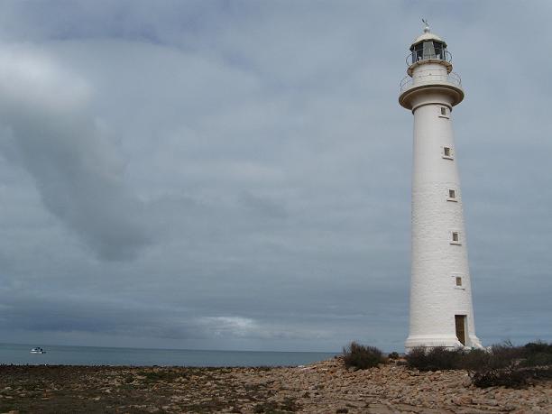

It’s a cute lighthouse and you can see where they added onto it in 1909 in the first photo above. Originally, built in 1883, it was 14 meters (45 feet) tall and fuelled by kerosene. The two cottages, also built in 1883, were for the light keepers, who manned the lighthouse for 90 years between 1883 and 1973. But in 1902, a ship ran ashore at Douglas Point so the tower was raised by 8 meters (25 feet). In 1973, this lighthouse was converted to electric and demanned. It was again upgraded in 1983, but turned off in 1993 by the Australian Maritime Safety Authority as it believed the lighthouse was no longer required. The Whyalla (nearest big town) City Council purchased the lighthouse with the help of the South Australia Government, and it was back in operation by 1995. The sign that welcomes drivers to the Eyre Peninsula has a photo of Port Lowly Lighthouse, as does the sign thanking drivers for visiting the Eyre Peninsula.

Some of the local wildlife and fishermen!!


On the drive to Port Lowly Lighthouse, I passed this funny sign and just had to stop!!
 YIKES!!!
After this, I drove for almost 4 hours to Port Lincoln. I stopped for gas in Whyalla and saw the navy ship (The Whyalla) and the sign heading to Mt. Laura. (Who is Laura and why are there so many places named after her?!?!)


After Whyalla, there is a town that has a ferry that saves about 3 hours driving, so I went to see what time I could take it heading back to Adelaide tomorrow. The ferry hasn’t run for about 3 years (I really should have gotten an updated road atlas!!) but there was this funny little light there. It kind of looks like it may have been from a lightship, but I couldn't find any information on it.

It was 4:30pm by the time I got to Port Lincoln, and since the next lighthouse is in a National Park which closes at 5pm, I decided I’d see it in the morning. Port Lincoln has a statue of Makybe Diva, the racehorse. She won the Melbourne Cup 3 years in a row, 2003, 2004 and 2005 and she is the highest stakes winner in Australia - $14,526,685! I don‘t know what that means, but it sure looks impressive! She didn’t come from Port Lincoln, but the owners did. It was one of those underdog stories, the owner was a hard working fisherman and then he made a lot of money fishing and so he bought a horse and she turned out to be a winner!! My view from the hotel room is great tonight!!!


Great Aussie Adventure - Day 10


The Troubridge Island Lighthouse in on the Investigator Strait between Kangaroo Island and the Yorke Peninsula. This lighthouse was needed as there were between 33 and 100 shipwrecks and groundings this area. In 1850, there were seven vessels that ran aground in an eight-month period. This lighthouse, built in 1855, was South Australia’s second lighthouse. It was constructed of cylindrical cast iron segments that was shipped out from the UK and bolted together on the island. The keepers cottages were completed in 1856. In 1889, the light was upgraded to a fixed red light. Between 1925 and 1931, electricity was provided by a petrol generator. In 1956, the light was again upgraded that increased the range from 10 Nautical Miles to 25. In this same year, the light was repainted bright red with a white horizontal band as its daymark. In the late 1970’s, it was decided to build the Troubridge Hill Lighthouse. The Island Lighthouse was downgraded, automated and demanned, with the new light. The light was extinguished in March 2002 and replaced by a beacon at Marion Reef. Also in March 2002, Troubridge Island Lighthouse was given the honor of being on a postage stamp. In 1802, the island was a sandbar on a limestone reef, and by 1838, it was a small inlet that was 600 meters (1,969 feet) long by 300 meters (984 feet) wide. Although it is now 800 meters (2,625 feet) long by 400 meters (1,312 feet) wide, it is erosion that is threatening the lighthouse now, as the edge of the island is currently right up the base of the lighthouse. The lighthouse has withstood an earthquake in 1902 which caused a fire to destroy the lantern room and damaged the foundations. The lantern room was repaired at this time for immediate service, but it was not until 1904 that the tower foundations and cottages were repaired. Because of the land erosion, there are no tours of the lighthouse or the island. This light flashes every 10 seconds, red and white. The red is visible for 7 Nautical Miles, while the white is seen for 10 Nautical Miles. It is 25 meters (82 feet) above sea level and is 24 meters (79 feet) tall.


The Troubridge Hill Lighthouse was built in 1980 to replace the Troubridge Island Lighthouse. This lighthouse is unique in that is was built from special wedge shaped clay bricks and has never been rendered or painted and the lantern room is fabricated fiberglass. Because of the wedge shaped bricks, this lighthouse is earthquake proof and was built to resist high winds. This light was built to be automatic and unmanned as the original apparatus was an array of sealed beam lanterns (like car headlights) that turned. However, this was expensive, so they were replace with a rotating lens and electric lantern. This lighthouse flashes twice in 15 seconds. It is 62 meters (203 feet) in elevation, is 32 meters (105 feet) tall and is visible for 22 Nautical Miles.

There was a big storm coming in and as I was leaving the lighthouse, the rain came.

But then it cleared up later as I was wandering around Innes National Park. In this park, I knew about 3 lighthouses, but there is actually 5!! Of the 3, I thought I could only see 2, but in fact I could see 4. Anyway, since this is a national park, there were signs all over telling drivers to watch out for emus, kangaroos and osprey. It was so weird, but I did see wild emus grazing and even 3 kangaroos hopping across the road! And one or two osprey in the air. It was great!

Here I saw Althorpe Island Lighthouse (in the distance on the island) and Cape Spencer Lighthouse. Built in 1879, the lighthouse on Althorpe Island was kept working by dedicated lighthouse keepers for 112 years until 1991 when it became automated. Lighthouse keepers brought goats, cats, sheep, wallabies and even a horse to the island, along with introduced weeds. To protect the native plants and animals, the island became a conservation park in 1972. (1972!!) Since then, volunteers and park staff have been removing the feral plant and animals from the island. Some of the volunteers even manned the lighthouse before it was automated. The island in 91.5 hectares in area, 1.6 km (0.99 miles) from North to South, 1.2km (0.75 miles) wide and is 91 meters (299 feet) above sea level. (Port Lincoln is 32 Nautical Miles further west - but it took me a full day to drive to Port Lincoln!!) The construction was begun in 1877, but it was not until February 14, 1879 that the light was lit and the 3 keepers cottages were finished. The lighthouse was built of limestone and hard sandstone found on the island. The spiral staircase was constructed of solid bricks of sandstone. The keepers cottages were also made from the hard and limestone found on the island. Although the lighthouse was in place, six shipwrecks were noted between 1877 and 1982. This lighthouse was originally powered by oil followed by acetylene gas and then converted to electric in 1963. It was finally converted to solar in 1991. Althorpe Island Lighthouse is 107 meters (351 feet) above sea level, is 20 meters (66 feet) tall and is visible for 24 Nautical Miles. It flashes for 0.1 second every 7 seconds.

The Cape Spencer Lighthouse was originally placed in Innes National Park in 1950 as an automatic light that was similar to a metal box with a river-style light on top. Then in 1970 it was upgraded to the current concrete lighthouse. This 1970’s lighthouse also replaced Althorpe Island Lighthouse. This light flashes three times every 15 seconds. It is 78 meters (259 feet) above sea level, is only 9 meters (30 feet tall) and can be seen for 23 Nautical Miles.
Cape Spencer and Althorpe Island

I had written on my trip planner that I couldn’t see West Cape Lighthouse, but since I was there, I drove to the area just in case. And wouldn’t you know it, I COULD see it!! It is very shiny!! It is called Simplex Munditiis which means “Elegant Simplicity” in Latin. It was built using stainless steel to minimise environmental impact during construction. This one was built in 1980! It is 8.5 meters (28 feet) tall.


 Pondalowie Bay Lightouse
And from here, I could see Wedge Island, but not the lighthouse on it as it’s too far away, and Pondalowie Bay Lighthouse, which is on South Island. The lighthouse on Wedge Island is only 5 meters tall, but is the highest above sea level in Australia at 206 meters. It was built in 1911. The Royal Australian Air Force installed a radar station on Wedge Island during World War II. Up to 50 men lived there, watching for enemy ships.
And the last thing I saw in Innes National Park was a funny little island called Chinaman’s Hat. I’m not exactly sure where the name came from, but if you squint your eyes and turn your head, you might be able to see a Chinaman’s Hat!!!!
After leaving Innes National Park, I drove to Corny Point and found the lighthouse there. I took the long winding road to the lighthouse along a long dirt road that ran along the coast. It was so pretty with the sun breaking through the clouds and the ocean and fields. Then there was Corny Point Lighthouse, of course.

The Corny Point Lighthouse was first lit on 1st of March 1882. It was attended by light keepers until 1920 when the light was converted to automatic acetylene and in 1978 converted to electrical operation. The range of the light is 35km (19 Nautical Miles). This lighthouse is located on the northernmost point of the foot of the Yorke Peninsula. It was originally built to protect the grain ships entering Port Victoria, Moonta Bay and Wallaroo in the Spencer Gulf. It’s other purpose was to protect the southbound windjammers that were endangered by sou-westers which could bring them in on the Web Rock or onto the reefs and shoals of Berry Bay and Daly Head. There were two sites chosen for the lighthouse, one on top of the hill and the other on a rise closer to the sea. The second site was chosen although it was less stable. Because of this, a large concrete base was constructed. The tower was built from local limestone. There were two keepers cottages built from local stone as well. The original light was a twin wick burner which used mineral oil. It was automated in 1920 and the keepers cottages and stores were demolished. A 240 volt mains powers was connected in 1978 to increase the power, but it was so powerful that it caused problems with reflection of white light over Web Rock and the red screen had to be adjusted again. The first time this problem occurred was with the first light keeper, when he noticed the lighthouse was not in proper working order. The white light was shining over Web Rock causing a shipping hazard. J. Dagweill, the first light keeper, placed a canvas screen so it covered the reef side and this seemed to help. This lighthouse is 30 meters (16 feet) above sea level, is visible for 19 Nautical Miles and is 16 meters (8.6 feet) tall. The light flashes four times in 20 seconds.
There are some interesting notes from the keepers log - 27th August 1888 - At 3.30 a.m. observed a most brilliant meteor to northward about 45 deg above the horizon like a fiery globe falling to within about 25 deg of the sea apparently exploding. Having a tail of light like a comet. The whole display lasting about 10 seconds and lighting up the whole district.


It was blowing a gale here and it was so cold with the rain starting again, so I hopped back in the car and drove to Wallaroo where I saw the lighthouse that was removed to the maritime museum. This one is the Tipara Reef Lighthouse. This lighthouse was necessary because Tipara Reef was hazardous to ships as it was only one meter of water in some areas. At first there was a lightship here, but it was unsuitable. Since Wallarroo and Moonta were so important as trade ports, the government agreed to place a lighthouse here in 1872. It was completed in 1877. Originally, the lighthouse was erected on screw piles driven three meters into the reef. A platform was constructed and a wrought iron tower was placed on top. It had two decks and was over 30 meters (98 feet) above sea level. The main deck had a watch room, keepers quarters, kitchen, workshops and water tanks. According to a sign near the museum in Wallarroo, The lighthouse is entrusted to four keepers three of who are always on duty at the light, while a fourth resides at Moonta Bay to keep up a shore watch and private means of communication and supply with the mainland. The shore watch is not, however, a monopoly, each keeper in turn taking one month’s land duty to three months in the lighthouse. Supplies and correspondence are bought from Moonta Bay once a week by the keeper on shore duty in a fine sailing boat which forms part of the equipment of the lighthouse, and a dingey is also provide in which the keepers can take short marine excursions for the purpose of varying their regulation fare with a fish diet. South Australain Register, 5 January 1884. The original lighthouse optics consisted of a single white flashing light but a red section was added in 1917. In 1920, the lighthouse was de-manned and the oil-fuelled lantern was replaced by an automatic light. In 1968, all of the original accommodations and associated fittings were removed. The light section was removed from the pylons in 1955 and relocated to this site (the museum.)
And then I drove to Kadina where I’m spending the night. It sure is cold here on the ocean, but today is the last day of fall, so I guess it’s to be expected!! But 8 lighthouses in one day is pretty darn good!!!
About Me

- Laura
- Denver, Colorado, United States
- I'm originally from Colorado, but I've been living in Australia for three years. Before that, I lived all over the U.S.: Washington State, Maine, California, Oregon, Nebraska, North Carolina, Arizona, New Mexico, Pennsylvania, and more... No, I'm not a military brat or a military wife; I was a traveling nurse for 5 years so I moved to a new city every 3 months. During my travels, I became intrigued with lighthouses and started making plans to photograph as many as I could in whichever state I was living (including the two in Nebraska!) My blog is about my trips to various lighthouses, as well as other interesting trips. I hope you enjoy reading, and leave a comment or two!